
For the past 8 years Hydrau-Tech, Inc. has conducted over 105 Plan of Action (POA) studies for scour critical bridges and for bridges with unknown foundations. After the 2013 floods in Colorado, Hydrau-Tech inspected over 80 bridges for scour damage and provided scour mitigation for 60 bridges. Currently, Hydrau-Tech is providing detail design for scour mitigation to 40 bridges across the entire State of Colorado. Highlights of this experience are available in Hydrau-Tech’s bridge scour experience brochure.
The HT_POA_Sites file provides an interactive map of all Hydrau-Tech, Inc. scour critical bridge sites for which a POA was prepared. The file can be opened and viewed using Google Earth on a phone, tablet, or computer (Google Earth must be downloaded and installed on whichever device is being used, it is available for free here). After opening the file in Google Earth, selecting a bridge Placemark will display the bridge characteristics, a site image, and links to the site’s report documents and additional images. Note that sites with a red icon are part of the most current POA task order.
| Structure ID | Region | River | Highway |
|---|---|---|---|
| A-15-A | 4 | Dale Creek | US 287 |
| A-15-Z | 4 | Draw, Cattle | US 287 |
| A-17-AD | 4 | Lone Tree Creek | I-25 ML |
| A-24-AO | 4 | Lewis Creek | SH 113 |
| A-24-L | 4 | Draw | SH 113 |
| A-24-M | 4 | Draw | SH 113 |
| A-27-N | 4 | Lodgepole Creek | US 138 |
| A-28-M | 4 | South Platte River | US 385 |
| A-28-N | 4 | South Platte River | US 385 |
| A-28-O | 4 | South Platte River | US 385 |
| A-28-P | 4 | South Platte River | US 385 |
| B-06-S | 3 | Fortification Creek | US 40 |
| B-16-FT | 4 | Cach La Poudre River | SH 14 |
| B-16-H | 4 | Spring Creek | US 287 ML |
| B-26-E | 4 | Six Mile Creek | SH 59 |
| B-27-A | 4 | Frenchman Creek | US 6 |
| B-27-E | 4 | Frenchman Creek | US 385 |
| C-09-AR | 3 | Yampa River | SH 131 |
| C-17-BL | 4 | Big Thompson River | I 25 SBND |
| C-17-C | 4 | Little Thompson River | SH 60 ML |
| C-17-CZ | 4 | Windsor Wash | SH 257 |
| C-17-F | 4 | Big Thompson River | I-25 Service Road |
| C-22-J | 4 | Beaver Creek | US 6 |
| C-22-N | 4 | Draw | SH 71 |
| C-26-A | 4 | Coyote Creek | SH 59 |
| D-02-A | 3 | Spring Creek | SH 64 |
| D-03-A | 3 | The White River | SH 64 |
| D-04-G | 3 | Strawberry Creek | SH 65 |
| D-11-Q | 3 | Draw | US 40 |
| D-15-A | 4 | St. Vrain Creek | US 7 |
| D-15-AI | 4 | North Boulder Creek | SH 119 |
| D-15-AP | 4 | Boulder Creek | US 36 |
| D-15-AQ | 4 | Boulder Creek | US 36 |
| D-15-AR | 4 | Boulder Creek | SH 7 |
| D-15-AX | 4 | Boulder Creek | SH 7 |
| D-15-B | 4 | Fourmile Canyon Creek | US 36 WBND and EBND |
| G-17-AN | 1 | West Plum Creek | SH 67 |
| G-17-M | 1 | East Plum Creek | SH 67 |
| D-16-DA | 4 | Boulder Creek | US 287 ML |
| D-17-AK | 4 | The St. Vrain River | SH 66 |
| D-20-T | 4 | Rock Creek | SH 52 |
| D-24-B | 4 | Surveyor Creek | US 34 |
| E-10-A | 3 | Colorado River | SH 131 |
| E-15-AH | 4 | South Boulder Creek | SH 170 |
| E-17-IE | 6 | South Platte River | I 270 ML EBND |
| E-28-W | 4 | Black Wolf Creek | US 385 |
| F-06-M | 3 | The Colorado River | I 70 Access Road |
| F-06-O | 3 | Elk Creek | I 70 ML WBND |
| F-06-P | 3 | Elk Creek | I 70 ML WBND |
| F-09-AF | 3 | Cottonwood Creek | I 70 ML EBND |
| F-09-L | 3 | Gypsum Creek | US 6 |
| F-12-AL | 1 | Corral Creek | I 70 ML WBND |
| F-15-CY | 1 | Clear Creek | US 6 |
| F-15-D | 1 | Clear Creek | I 70 |
| F-16-AV | 1 | North Turkey Creek | US 285 |
| F-19-E | 1 | Draw | US 36 |
| F-20 BL | 1 | East Bijou Creek | I 70 WBND and EBND |
| F-20-BM | 1 | East Bijou Creek | I 70 WBND and EBND |
| F-22-E | 4 | Draw | US 36 |
| G-07-B | 3 | Cattle Creek | SH 82 |
| G-11-C | 3 | The East Fork Arkansas River | SH 24 |
| G-17-AL | 1 | Draw | SH 105 |
| G-18-BC | 1 | West Cherry Creek | SH 83 |
| G-18-H | 1 | Antelope Creek | SH 83 |
| G-19-A | 1 | Station Creek | SH 86 |
| G-21-F | 1 | Agate Creek | I 70 EBND |
| G-25-D | 1 | Sand Creek | US 24 |
| G-25-F | 1 | Sand Creek | SH 59 |
| G-26-B | 1 | Spring Creek | I 70 WBND |
| G-27-E | 1 | Sand Creek | US 385 |
| H-02-GC | 3 | The Colorado River | SH 340 ML |
| H-02-S | 3 | The Colorado River | SH 340 ML |
| H-02-FM | 3 | Little Salt Wash | I 70 WBND and EBND |
| H-02-FN | 3 | Little Salt Wash | I 70 WBND and EBND |
| H-02-FO | 3 | Big Salt Wash | I 70 WBND and EBND |
| H-02-FP | 3 | Big Salt Wash | I 70 WBND and EBND |
| H-03-L | 3 | Plateau Creek | I 70 |
| H-03-Z | 3 | Lewis Wash | I 70 Business Route |
| H-04-G | 3 | Big Creek | SH 330 |
| H-04-S | 3 | Plateau Creek | SH 330 ML |
| H-04-Z | 3 | Plateau Creek | SH 330 ML |
| H-07-H | 3 | East Muddy Creek | SH 133 |
| H-11-AA | 3 | The Arkansas River | SH 300 |
| H-11-U | 3 | Lake Fork Creek | SH 300 |
| H-13-G | 1 | The South FK South Platte River | US 285 |
| H-13-R | 1 | The Middle FK South Platte River | SH 9 |
| H-13-S | 1 | The Middle FK South Platte River | SH 9 |
| H-25-M | 1 | East Spring Creek Tributary | SH 59 |
| I-02-B | 3 | Gibbler Gulch | SH 141 |
| I-03-A | 3 | The Gunnison River | SH 141 |
| I-04-K | 3 | The Gunnison River | US 50 EBND |
| I-04-M | 3 | The Gunnison River | SH 65 |
| I-05-V | 3 | Gunnison River | SH 92 |
| I-06-C | 3 | The North FK Gunnison River | SH 187 |
| I-06-M | 3 | Hubbard Creek | SH 133 |
| I-13-I | 1 | Agate Creek | US 24 |
| J-01-C | 3 | The Dolores River | SH 141 |
| J-01-D | 3 | John Brown Creek | SH 141 |
| J-05-X | 3 | The Uncompahgre River | SH 348 |
| J-09-AB | 3 | Gunnison River | US 50 ML |
| J-09-B | 3 | Gunnison River Branch | US 50 |
| J-09-C | 3 | Gunnison River Branch | US 50 |
| J-09-D | 3 | Gunnison River | US 50 |
| K-01-A | 5 | Dolores River | SH 141 |
| K-01-C | 5 | Dolores River | SH 90 |
| K-08-D | 3 | Cebolla Creek | SH 149 |
| K-14-X | 2 | Texas Creek | Sh 69 |
| K-18-P | 2 | Blue Ribbon Arroyo | SH 96 |
| L-02-F | 5 | Dry Creek | SH 141 |
| L-07-A | 3 | Lake Fork Gunnison River | SH 149 |
| L-16-R | 2 | South Hardscrabble Creek | SH 165 |
| L-17-CD | 2 | Boggs Creek | SH 78 |
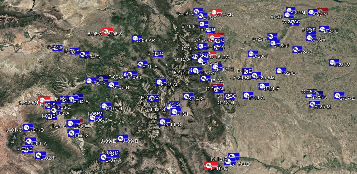
Download Link: HT_POA_Sites
Stream Gage Download Link: HT_StreamGages