
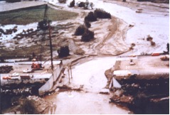
The Interstate 5 bridge that collapsed near Coalinga, California in 1998 carried up to 25,000 vehicles per day over Arroyo Pasajero Creek. Caltrans officials say they may never know why the bridge collapsed, but they have suggested two possible scenarios. According to the first scenario the water was so high and fast that it swept the bridge off its foundations; in the second scenario the intense flow scoured the bed below the pilings and knocked the foundation out from under the bridge. The bridge was built in 1967 and was 120 feet long and 40 feet wide. Pilings were 12 feet deep. Figures 1 through 3 show the failed bridge. As a part of BRI-STARS (BRIdge Stream Tube Alluvial River Simulation) model development and enhancement project, the Interstate 5 bridge and the Arroyo Pasajero Creek segments immediately upstream and downstream from the bridge were simulated. Using the topographic, hydrologic and sediment data provided by the U.S. Geological Survey, the magnitude of scour due to the scouring action of flows were computed to determine the cause of failure. Simulations showed that, up to 11 ft of additional scour took place at the bridge opening; and therefore the bridge failure was due to the scenario involving intense scour of foundation.
BRI-STARS was developed by Dr. Albert Molinas, President, Hydrau-Tech, Inc. for the Federal Highway Administration (FHWA) to solve complex alluvial river sedimentation problems. This semi-two-dimensional model divides the stream channel into a series of stream tubes. Stream tubes are imaginary tubes bounded by streamlines. They carry a constant discharge along their length. Water and sediment is routed along each stream tube by satisfying the governing flow and sediment transport equations. BRI-STARS utilizes both the conservation of momentum and energy equations to compute water surface profiles through sub-critical, supercritical, and combination of both flow types involving hydraulic jumps. State-of-the art sediment transport equations, bridge scour relationships, sediment sorting algorithms are used in computing the various scour and deposition processes in river systems.
BRI-STARS is a visually interactive model; users can follow the progression of computations through simulation times. Lateral scouring and deposition process as well as longituduinal changes can be viewed through animation of cross section changes or the thalweg profiles. Changes in channel topographies, velocity variations along the channel and across the tubes are color coded and displayed in separate windows.
Figures 4 through 6 show the windows displaying the various aspects of computations during the simulation run for the Interstate 5 bridge scour study. Figure 4 shows computed scour patterns at the bridge site and vicinity. Figure 5 displays the thalweg profiles at the beginning and end of flooding event; it also shows cross sectional changes through the bridge and immediately downstream. Figure 6 displays computed 2 dimensional velocity field along the study reach through the contracted bridge opening.
The computed scour compared very closely with the measured scour determined from a detailed field analysis conducted at a later date by U.S. Geological Survey. The numerical simulation clearly demonstrated that the bridge failure was due to excessive scouring of the foundation.
 Numerical Simulation of Interstate 5 Bridge Failure near Coalinga, California
 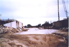 Figure 2. View of the failed bridge from the channel facing downstream. Note the failed left abutment.
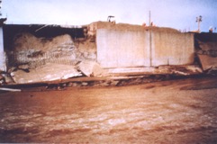 Figure 3. View of the failed bridge from the channel facing downstream. Note the failed left abutment.
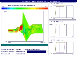 Figure 4. Topographic Changes window of BRI-STARS model showing the red-colored bridge scour zone and the blue- colored deposition immediately upstream from bridge for comparison with Figure 1.
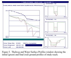 Figure 5. Thalweg and Water Surface Profiles window showing the initial (green) and final (red) ground profiles of study reach.
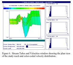 Figure 6. Stream Tubes and Velocities window showing the plan view of the study reach and color-coded velocity distribution.